


Hiking Table Mountain’s three peaks in one day is tough and not for the faint-hearted. Here’s how we did it.

Last weekend I did something I’ve been wanting to do for years: hike all three Table Mountain peaks in one day – all without putting a foot on my least favourite route, Platteklip Gorge. It’s not a hike for the faint-hearted, but if you’re reasonably fit, aren’t scared of heights, and (importantly) can find someone who’s been through the tricky sections before, then it’s hard to imagine a more exciting and rewarding way to hike on Table Mountain.
Be aware, however: this is not an easy day out. Hiking Table Mountain’s three peaks in a day is tough (for a more relaxed hike, check out these five hikes and walks in Cape Town). From UCT to the parking lot at Lion’s Head took nine hours and, except for our (necessary) slow decent on Kloof Corner, we didn’t dawdle. There are also plenty of exposed paths and some tricky scrambles up near-vertical rock faces, especially on the eastern ascent of Devil’s Peak and the ledges route from the saddle up to Maclear’s. The first chain down Kloof Corner is also worth mentioning – it’s a six-metre drop into a narrow crack with a 200-metre vertical drop on the right-hand side. Exhilarating, but not for anyone who isn’t confident with heights. If there’s any wind at all, find something else to do for the day.
My final disclaimer is just this: don’t try hiking Table Mountain’s three peaks alone, or without someone who has done it quite recently and knows the way. In particular, the ledges route up from the saddle is steep, poorly marked and involves a few sections of proper climbing. There are no signs and only a couple of cairns here and there to mark the way. You have been warned.

There are three main routes to the top of Devil’s Peak. The most direct goes from the blockhouse, up over the knife edge and around the ‘front’ (eastern) face, involving a little scramble up through a couple of cracks just below the peak itself. The western side is safer, with clear paths all the way. Head around to the west if you are unsure.

Taking a break on the north buttress ledges. The ascent is steep and tricky and not advisable if you don’t have someone in your group who knows the way. Keep a close eye out for the cairns and two sections in particular: when the path goes under a low ledge (there is no climbing involved until the waterfall at the end of the path), and the waterfall: do not climb the waterfall itself. There is a rock face just before where a safer route is marked with a small cairn.
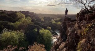
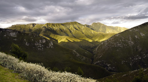
Following the ledges up from the saddle to Maclear’s Beacon is not easy. The path disappears in the thick undergrowth and it’s easy to lose your way. The views, however, are fantastic.

Peak number two: Maclear’s Beacon. The highest point on Table Mountain. Look out for the rather strange metal plaque dedicated to Jan Smuts on the ridge below the beacon – to the right of this photo.

From the top of Platteklip Gorge there is another, far more interesting (and difficult) route down Table Mountain. In fact there are two. The ‘India Venster’ route starts with this helpful sign, and then splits around the corner with one path heading down the main route, and another branching off below the electricity pylons to Kloof Corner.

The first chain on Kloof Corner. With a 200 metre drop on one side, a chain hangs down into a deep crack in the rock. First lower your bags, then swing out to the right onto an exposed ledge before cutting back into the crack and exiting on the left hand side.

The bottom of the first chain on Kloof Corner. Not for the faint of heart.

The second chain is also long and vertical with few foot holds to work with. Easiest to just trust the chain completely and abseil backwards down the cliff.

All’s well that end’s well. Exhausted but happy on Lion’s Head that afternoon.
I logged our route on Endomondo Sports Tracker. Here’s the track it recorded.
For more information on hiking, and safety on Table Mountain visit the SANParks Table Mountain National Park safety page
Table Mountain National Park emergency contact number: 086 110 6417