
One of our favourite hikes is in the Jonkershoek Nature Reserve, which lies near to the town of Stellenbosch. The Jonkershoek mountains, with their high peaks and deep kloofs, form part of the larger Boland mountain range (part of the greater Hottentots Holland Nature Reserve).
The Eerste, Berg, Lourens and Riviersonderend rivers all have their sources high in these mountains. The mountainous topography has a significant effect on the rainfall, (can be as high as 3.6m per year!) which is one of the highest in South Africa. Snow is not unusual on the higher peaks during the winter months.
The natural vegetation of the Jonkershoek area is mainly mountain fynbos. More than 1 100 plant species are known to occur, of which a number are rare and/or endemic to the area. Mammals include leopard, honey badger, baboon, klipspringer, mongoose and numerous smaller animals like mice, shrews and rats. Most of these are shy, however, and seldom seen. Large raptors such as black eagle (which we spotted) , the occasional fish eagle and spotted eagle owl occur, while kingfishers and typical fynbos birds (sugarbird, orangebreasted sunbird and protea seed-eater) are more abundant.
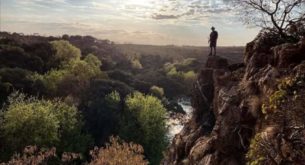
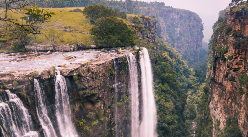
There are a number of beautiful hikes in the area, ranging from a gentle amble to the ‘big daddy hikes,’ which we did. A walk through the wild flower garden will only take you about 30- 45 minutes. However, if you are really adventurous and have a reasonable level of fitness, you can do the Swartboskloof hike, which is 18km. This trail leads via Kurktrekkernek to Witbrug. Hikers face a steep 4.5km ascent followed by a fairly level top section. The ascent and the descent are fairly technical and require good walking shoes and a stick as the shale sections are very slippery. Once at the top, the summit flattens out, offering you a panoramic view of False Bay. This is a good time to take a break and have your ‘lunch’ or picnic. The descent is a steep 2.6km hike down Kurktrekker, joining the Tweede Waterval route. The waterfalls on route are a great place to have a swim. Once you reach the road, you still have another 2km walk back to the parking area. This is an easy stroll on a gravel road.
Be sure to pack enough water and a warm jacket, as it is a long hike and can get cold at the top.