
At just 120km long, the Rwenzori mountains are hardly the longest in the world. But each of its six peaks – all of them more than 4 500m tall – has its own unique story. Matthew Holt went to learn more and climbed each of them
I was getting quite skilled at negotiating bogs, springing between firm tussocks and partially submerged logs. After two days’ constant rain, shafts of sunshine warmed my face and sunbirds darted between towering lobelia stalks. What a magical place. Then the tussock crumpled beneath me, my trekking pole sank to the hilt and my wellies filled with mud.
‘I wish that some person devoted to his work, some lover of Alpine climbing, would take the Rwenzori in hand and make a thorough work of it,’ challenged Henry Morton Stanley to the Royal Geographical Society in 1901.
Just north of the equator, on Uganda’s border with the Democratic Republic of the Congo, the Rwenzori have been linked to the fabled Mountains of the Moon, which – according to ancient geographer Ptolemy – fed the Nile with their snows.
Despite topping 5 000m, the first European sighting wasn’t until May 1888, by Stanley during his expedition to rescue Emin Pasha, the governor of a remote colonial outpost, from which fewer than 200 of Stanley’s 700 men returned.
The trip’s moral descent was neatly captured when Irish whiskey heir James Sligo Jameson bought a 10-year-old African girl for six handkerchiefs, gave her to cannibals, and sketched her being eaten. But, on the plus side, the expedition located the nebulous Lunar Mountains. Stanley renamed them Rwenzori, which he incorrectly thought was the local word for “rainmaker”.
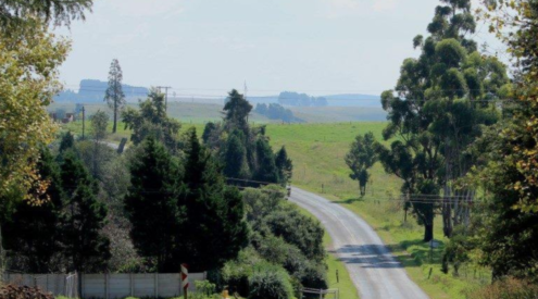
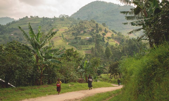
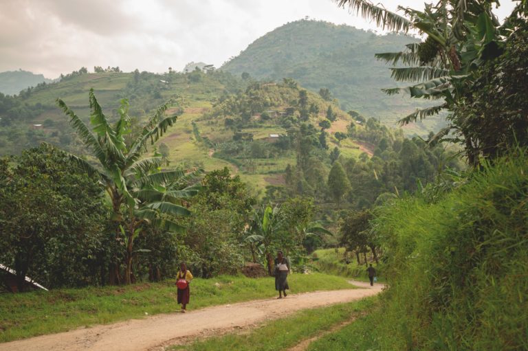
My wife and I had visited the Rwenzori 20 years earlier, but hardly made a thorough work of it, climbing just two of the six major massifs. We drove 400km due west, through bustling villages, over potholes and up and down rolling hills bursting with tea, coffee and bananas. A week too early for the “Bye Bye Lockdown Massive Disco”, we spent a quiet night in Kasese, before progressing to the trailhead at Nyakalengija, collecting wellington boots and our retinue.
We had two local guides, the athletic Johnson and the veteran Denis; an innovative cook named Lazarus, plus eight hardy porters. They were all from the Bakonzo tribe, who believe the Rwenzori are home to the great spirit Kitasamba, the snow being his frozen semen – well, that’s what I’ve read.
Having read Stanley’s obituary in The Times, which quoted his Rwenzori challenge, the Duke assembled a team of surviving companions, including renowned photographer Vittorio Sella and four Alpine guides.
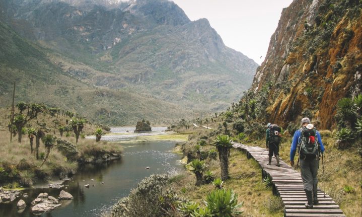
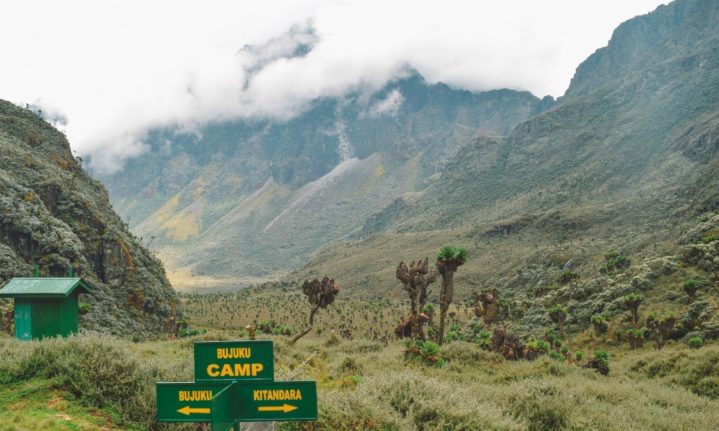
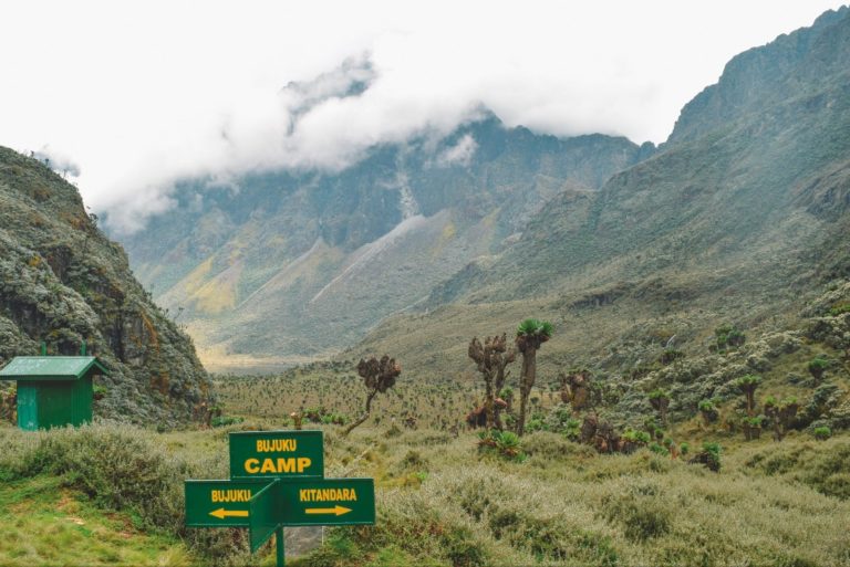
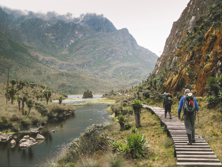
For the first two days, we followed the standard trekking circuit up the Mubuku Valley and then along the Bujuku River to John Matte Hut. The path was well cut; the huts comfortable, if slightly shabby.
On the third morning, however, we left the main trail and branched up the Mugusu Valley. The route instantly became an obstacle course of tangled vegetation that collapsed under our weight, and glutinous mud that sucked off our wellies – and it took six and a half hours to cover 5km up to Roccati Pass. Named after the Duke’s zoologist, this squelchy col at 4 200m separates Mount Gessi from Mount Emin, overlooks Lac de la Lune, and marks the frontier. ‘The Congo,’ announced Denis portentously, before adding less reliably that a helicopter landed here in 1932.
We stayed two nights on the pass, Fiona and I in a small tent, Denis and crew huddled under a shallow overhang. Despite insalubrious lodgings, they were irrepressibly cheerful, chatting animatedly and taking turns to forage wood for a smoky fire and stir their communal pot of gloopy manioc.
The first peak we tackled was the fifth highest massif, Mount Gessi (4 715m), named after an Italian adventurer who in 1876 circumnavigated Lake Albert by boat, fending off hostile locals and hippos. As we packed for the day, I asked Denis if it might rain. He sniffed the air and deliberated.
‘It can,’ he replied, ‘and it cannot.’ To be fair, though we’d come in January during one of two dry seasons, “dry” is a relative concept here.
We set off at sunrise, which occurred abruptly at 7am, without any fanfare or visible sun. After our delays, it was a relief to be climbing, though that mood soon evaporated when we moved on to slabs carpeted in spongy, damp moss that peeled off underfoot. On Johnson’s advice we’d brought ice axes, which initially seemed daft, but soon we were desperately scraping for traction.
The following day, we crossed the col to Mount Emin (4 798m), named after the object of Stanley’s torrid relief expedition, who had started life as a German Jew; converted to Islam; governed a querulous Egyptian province near Lake Albert; didn’t want rescuing; on being escorted by Stanley to Bagamoyo, fell off a roof terrace, drunk; and shortly after that, was killed in the Congo by slave traders who slit his throat. But then the Duke named the mountains after explorers, not saints.
Bashing through a maze of giant groundsels and lobelias, we reached a steepening gully. A few decades earlier, this had been glaciated and safely stomped up in crampons – but now the ice had gone, leaving behind loosely stacked boulders. It took a fraught three hours to get up and almost as long to get down.
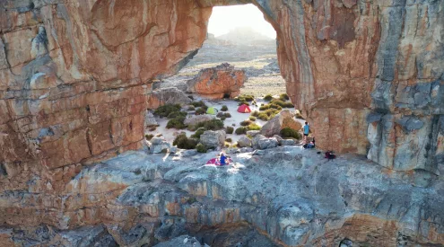
That night, we camped halfway down the Mugusu Valley, pitching our tent in knee-deep heather. Meanwhile, our retinue squeezed into Skull Cave – where, in 1949, the wife of a colonial administrator found a biscuit tin containing a human skull and was promptly struck down ill, needing to be carried out strung on a pole. Denis offered to show me where the skull was hidden, but thankfully couldn’t find it.
Re-joining the main trail, the following day we crossed the Bigo Bog, which had allegedly swallowed people whole, but was now emasculated by boardwalks. Further on, however, once the boardwalk petered out, we had to tread a narrow, sometimes non-existent, line between knee-deep mire and Bujuku Lake.
Bujuku Hut served as our springboard for Mount Speke (4 890m), honouring John Hanning Speke who in 1858 became the first European to see Lake Ukerewe, which he rechristened Victoria and correctly identified as the source of the Nile – though he was dead before this was generally accepted, having shot himself.
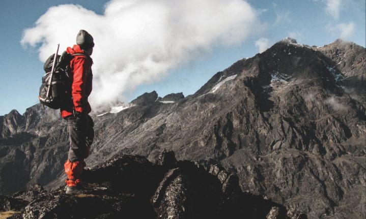
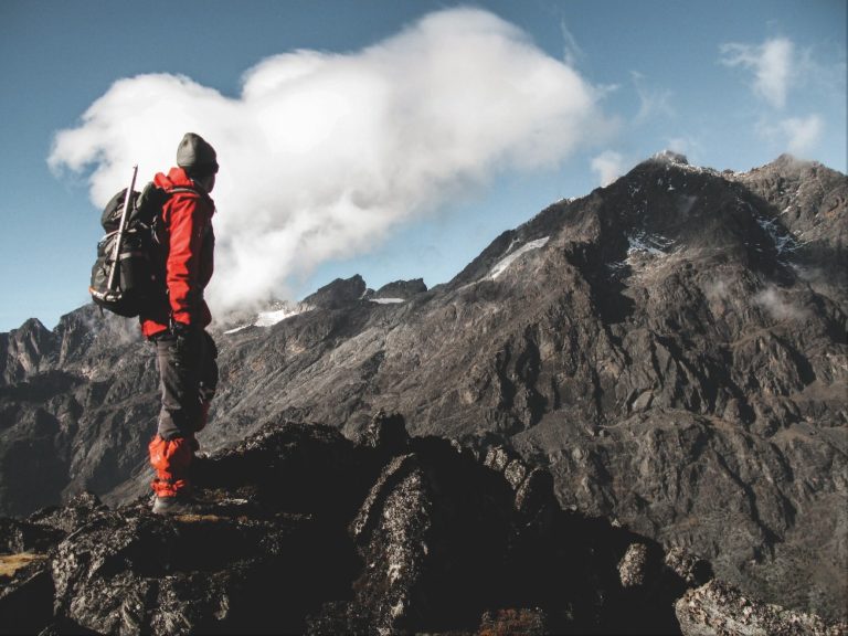
Like our two previous peaks, Mount Speke took three hours to summit, but this time the mountain seemed properly stuck together, the holds stayed attached, and I actually enjoyed the outing rather than thinking it might be my last. From the summit, we looked across to the following day’s target and Rwenzori’s highest massif, Mount Stanley.
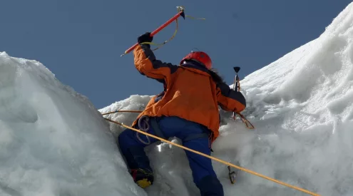
Steeled for a long summit day, and the first on which I’ve used both wellies and crampons, we left the Bujuku Hut at 2.30am, under a starless, ink-black canopy. Come dawn, we’d reached the Margherita Glacier and the visibility was worse, with dense cloud enveloping us. Nonetheless, we dutifully donned sunglasses, for the Duke’s team had neglected to wear theirs and gone snow-blind, having to bathe their eyes with tea. ‘Helmets are also very important,’ noted Johnson disconcertingly, since none of us had one.
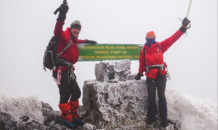
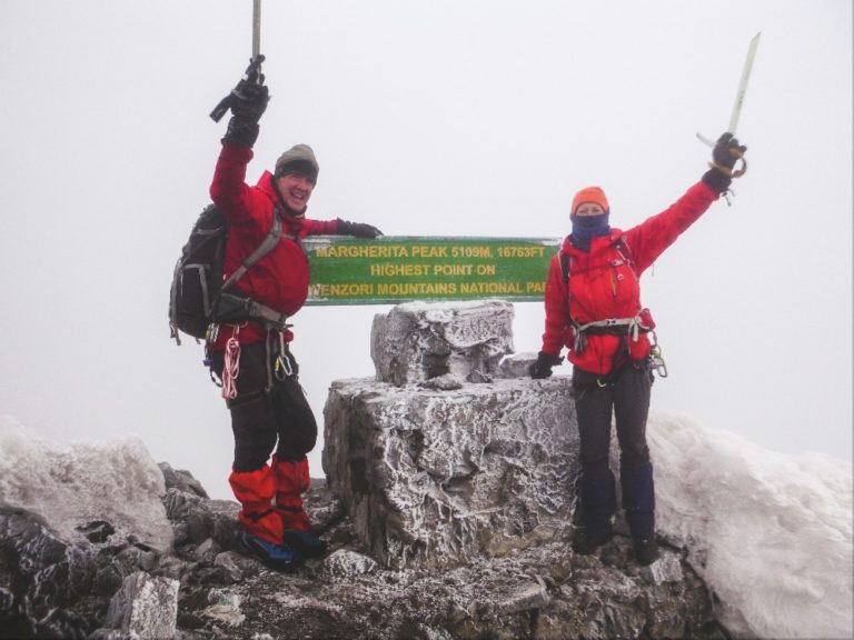
We cramponed up grubby ice, till we were blocked by an eroded serac and awkward cliff, which the Duke’s party had surmounted by one of his guides standing on another’s head in hobnailed boots. Fortunately, however, there was now a fixed rope to assist us. From here, a brief scramble led to signs proclaiming we’d reached Margherita Peak, Uganda’s high point at 5 109m, which the Duke named after his aunt, the former Queen of Italy – though she’s more widely known for the pizza baked in her honour.
We descended via the Elena Hut and Scott Elliot Pass, progressing from slippery ice to slippery rocks to slippery mud. Meantime, it snowed, then hailed, then rained, and by the time we reached Kitandara Hut, having been out 14 hours, we were soaked. On the shore of a mirror lake and looking picturesque from above, the hut was a dilapidated shed, with some half-broken furniture and a stack of wooden shelves serving as bunks. Our discomfort was complete when a large group of sodden Israelis stumbled in.
Our next target was Mount Luigi di Savoia – the lowest of the six massifs – but everything was too wet. Besides, despite bearing his name, this was the only major peak not climbed by the Duke – who called it Mount Thomson, after a relatively obscure Scottish explorer. The Duke subsequently assented to a proposal from the Royal Geographical Society to commemorate himself.
We did, however, buck up sufficiently to move up to Freshfield Pass, where we set up camp. By the next morning we’d recovered our resolve to climb Mount Baker (4 843m), named after Samuel Baker, the English explorer who was the first European to see Lake Albert in 1864, along with his Hungarian-born wife, Florence, whom he’d rescued from an Ottoman slave market.
For most of our outing, it snowed or drizzled. And when we occasionally thought the sun might break through, it didn’t. Nonetheless, the scrambling was interesting rather than terrifying, and the five-hour return trip was probably the most enjoyable of our Rwenzori summits.
It took two days to walk out from Freshfield Pass, down greasy wooden ladders and through malevolent slime. When we finally reached the park gate at Nyakalengija, a sign reminded us that the Rwenzori are a magical challenge, but I was very relieved to be out.
The Duke returned home from his five-month expedition to a hero’s welcome and an attractive American heiress 13 years his junior. But thereon his trajectory was downward. In 1909, he led an expedition to K2, which didn’t get very high; his romance fizzled out due to staunch opposition from the Italian royal family; and during WWI he was unfairly sacked as Italy’s naval commander. After the war, he moved to Somaliland where he set up a model farm and lived with a young Somali woman, till he died from cancer, aged 60.
Back in Kasese, we celebrated our trip and my birthday with pizza and Nile Special beers. I was now the same age as the Duke when he died, but there the similarities end.
Trip Planner
The standard circuit can be hiked in six days, overnighting in huts. While not technical, it’s certainly rugged and challenging, with two passes of more than 4 000m, steep ladders, slippery rocks and bogs to test your sense of humour. Climbing any of the six major peaks will typically add an extra day per peak. All require some scrambling, with the highest, Margherita Peak on Mount Stanley (5 109m), also involving short glacier crossings. They’re all accessible to any fit, determined beginner, if somewhat tricky when wet (which is often).
Organising Your Trek
There are two established local operators, each with their own separate routes and huts in the park. Rwenzori Mountaineering Services (RMS) is a community-based organisation, has more experienced technical guides and starts/finishes at Nyakalengija. Rwenzori Trekking Services (RTS) operates from Kilembe, has newer, plusher huts and is a bit more expensive. RTS might be the better option if you just want to hike the standard circuit; RMS if you want a tailored itinerary and/or to climb more peaks.
The standard six-day hike costs about $1 100 per person, from Kasese. Expect to pay about $1 300 pp for a trip to climb Margherita Peak. Our two-week trip with RMS to climb all the major peaks, plus accommodation in Entebbe and Kasese, and all transfers cost $3 500 pp.
When To Go
The two dry seasons are supposedly from mid-December to March, and from mid-June to September. But you should always be prepared for rain.
What To Take
Your operator will provide you with a gear list. But, besides several changes of standard hiking clothes and lots of socks, you’ll need good waterproofs, dry bags, trekking poles, and a warm jacket and sleeping bag (temperatures can drop to freezing). An umbrella might look silly but can be useful; and if you have wellies, take them for the bogs (otherwise RMS can provide). If climbing the peaks, you’ll also require a harness, ice axe, crampons (or micro-spikes), karabiners, helmet and rope (which can be hired at the gate). The catering is filling but can be a bit dull, so you may want some snacks and luxuries to liven it up – plus coffee and a percolator if you need a proper brew to start the day. Don’t worry, you’ve got porters to carry all this for you. The best map of the region is Rwenzori Mountains Map and Guide by Andrew Wielochowski (EWP). You can’t get it there, so purchase it in advance.
What Else To Do
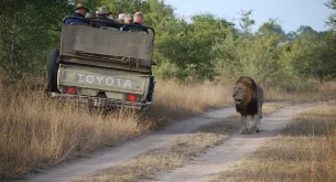
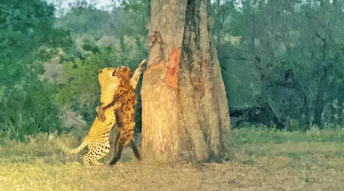
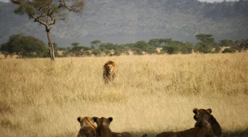
If you have a spare day, Kasese is on the doorstep of the Queen Elizabeth National Park, which has the Big Five. By East African standards, the fees and accommodation are affordable.
Highlights include a boat trip on the Kazinga Channel and visiting the famous tree-climbing lions.
Visit the website to discover more details about balloon safaris, chimp tracking, bird-watching, boat cruises and cultural tours. queenelizabethnationalpark.com
To book a tour, visit queenelizabethnationalpark.com
Prices are not listed on the website and they recommend not trying to tour by yourself.
Words: Matthew Holt
Photography: Matthew Holt, Fiona Mcintosh and Gallo images/Getty/Alamy
A version of this article originally appeared in the August 2022 print edition of Getaway
Follow us on social media for more travel news, inspiration, and guides. You can also tag us to be featured.
TikTok | Instagram | Facebook | Twitter
ALSO READ: Freedom Express: Horseback riding through Namibia’s badlands