


Satellite technology is being used to keep track and help identify Elephants from space.
Through a combination of the commercial earth observation satellites Worldview 3 and 4 and a computer deep learning algorithm, researchers are now able to capture detailed images of African elephants moving through grasslands and forests.
Not only are these two pieces of technology able to capture African elephant numbers, but it can automatically do so with the same level of accuracy as a human.
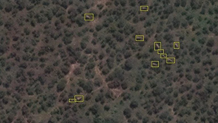
This is what the algorithm sees when picking out an elephant against a complex backdrop such as a forest. Credit: Satellite image 2020 Maxar Technologies
The deep learning algorithm was developed by Dr Olga Isupova from the University of Bath, and could allow both researchers and conservationists to scan and assess vast areas of landmass in a matter of minutes.
Current methods for assessing a particular area involves the use of low-flying planes, which not only disturbs the wildlife but also takes a considerable amount of time.
‘Accurate monitoring is essential if we’re to save the species,’ said Dr Isupova in an interview with The Independent. ‘We need to know where the animals are and how many there are,’ Isupova added.
This method of tracking and monitoring wildlife also ensures that habitats will not be disturbed or ruined by vehicles used to track animals. It also makes it possible to track large groups of animals as they cross borders that conservationists may not be able to cross.
According to The World Wide Fund for Nature, a combination of Poaching and damaged habitats has caused the population of African Elephants to plummet over the past century, as there are just 415,000 elephants remaining across Africa.
Picture: Pixabay