






A new long-distance hiking route in Japan is giving travellers another reason to explore beyond the country’s major cities.
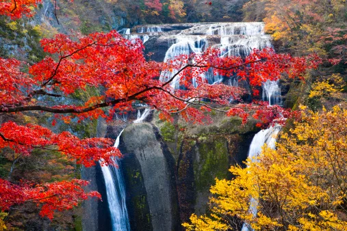
Daigo-machi, Kuji, Ibaraki Prefecture, Japan/By: HISAO OSONO/a.collectionRF/Getty Images
The Hitachinokuni Long Trail, now fully open after seven years of development, stretches for 320km through northern Ibaraki Prefecture, linking six cities and towns with a mix of mountains, rural landscapes, waterfalls, beaches and historic sites.
The route was first announced in 2019 by Ibaraki Prefecture and the Hitachi Province Trail Club. It officially opened in full in September 2026.
According to Euronews, the circular trail connects Kitaibaraki, Takahagi, Hitachi, Hitachi Ota, Hitachi Omiya and Daigo, all less than two hours from Tokyo by train.
Rather than focusing solely on wilderness, the trail passes through landscapes known as satoyama. These are traditional rural areas where communities have lived alongside mountains, forests, fields, ponds and rice paddies.
The route also offers plenty of variety, from mountain hikes and waterfalls to coastal scenery and remnants of Japan’s history.
Five sections to explore
The circular route is divided broadly into five areas, allowing hikers to choose individual sections rather than attempting the entire 320km trail.
Central area
The Central Area is one of the more demanding sections, with repeated steep climbs and descents through the Yazimo mountain range near Daigo.
The effort is rewarded with views of Fukuroda Falls, one of the region’s best-known natural attractions, as well as the rocky peaks of Okukuji Nantaiyama and the Ryujinkyo Gorge.
This section is better suited to experienced hikers, particularly because of its more challenging terrain.
Northeast area
The northeastern section combines mountain and coastal scenery.
The route passes peaks including Eizomuro and Hanazono Yama before reaching the coast, where hikers can visit Kohama and Sasaki beaches.
There is also a strong historical element here. The trail follows the Salt Road, an old trade route, as well as the Jikkoku Canal, which dates back to Japan’s Edo period, between 1603 and 1868.
Southeast area
The southeastern section begins in Hananuki Valley, with the route climbing towards Mount Tsuchidake and its views over the surrounding landscape.
Waterfalls and historic sites feature along the way, including the ruins of Kitadaimon Castle, before the route reaches the Kuji River.
This section was first opened in 2024 as part of the trail’s gradual development.
Southwest area
In Hitachiomiya, the southwestern section winds through mountainous landscapes rich in plant and animal life.
One of the area’s botanical highlights is the Iwauchiwa flowering plant. The route also passes through a former gold-mining area, adding another layer to the landscape’s history.
Northwest area
The northwestern section includes Mount Yamizo, where hikers can combine mountain scenery with cultural and historical sites.
Among them is Yamizomine Shrine, believed to date back as far as the first century. At the summit, a castle-shaped observation deck offers panoramic views towards the mountains of Fukushima and Tochigi prefectures.
A year-round hiking option
The trail’s relatively moderate elevations and geography mean it is not heavily affected by snowfall, making it potentially accessible throughout much of the year.
However, hikers should plan carefully. There are limited opportunities to refuel along parts of the route, while some sections are rocky and others involve steep slopes.
The circular design also means visitors don’t have to commit to all 320km. The trail can instead form part of a wider Ibaraki itinerary, making it possible to explore individual sections alongside nearby towns, cultural attractions and natural landmarks.
Follow us on social media for more travel news, inspiration, and guides. You can also tag us to be featured.
Instagram | Facebook | Twitter | Spotify
ALSO READ:
Why thousands of ladybirds are washing up on Western Cape beaches