



Deep in Colombia’s Sierra Nevada de Santa Marta rainforest, ancient stone terraces emerge from a landscape of towering trees, rushing rivers, and mist-covered mountains.
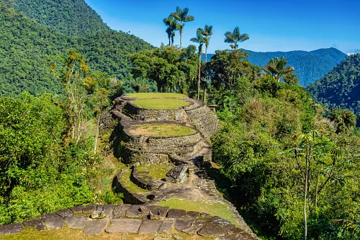
Hidden ancient ruins of Tayrona civilization Ciudad Perdida in the heart of the Colombian jungle Lost city of Teyuna. Santa Marta, Sierra Nevada mountains, Colombia wilderness/By: Artush/
iStock
Known as Ciudad Perdida, or the Lost City, this remarkable archaeological site offers a glimpse into the achievements of the Tayrona civilisation and the Indigenous heritage that continues to shape the region today.
The multi-day trek winds through tropical forest, crosses rivers, and follows steep mountain trails before reaching a network of stone platforms built centuries ago. Yet Ciudad Perdida is more than a remote archaeological discovery. Known to Indigenous communities as Teyuna, it lies within ancestral territory where cultural traditions, spiritual beliefs and environmental stewardship remain closely connected to the land.
An ancient settlement in the mountains
A glimpse into the Tayrona civilisation
Ciudad Perdida is located on the northern slopes of the Sierra Nevada de Santa Marta, a mountainous region rising dramatically from Colombia’s Caribbean coast. Archaeologists generally date the settlement’s earliest occupation to around the seventh or eighth century, although its development continued over several centuries.
Built by the ancestors of the region’s Indigenous peoples, Teyuna became an important centre within a wider network of settlements connected by mountain pathways. Its elevated position above the Buritaca River basin placed it within a landscape of exceptional ecological diversity, where tropical forests meet the changing climates of the mountains.
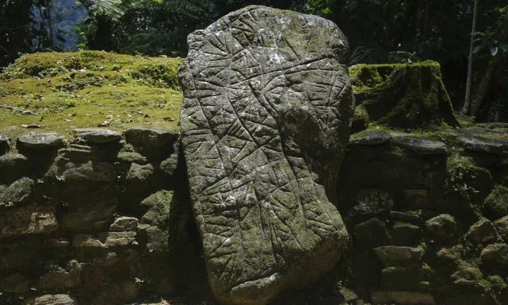
The settlement was not a city of monumental stone palaces. Instead, its architecture reflects a sophisticated understanding of the terrain, with carefully constructed terraces, stone stairways, retaining walls and circular platforms adapted to steep hillsides.
A city shaped by the landscape
More than 200 archaeological structures have been identified at the site. Stone terraces supported circular houses constructed from perishable materials such as timber and thatch, while paved paths connected different parts of the settlement.
The builders also developed systems to manage rainwater and stabilise the slopes. Retaining walls supported the terraces, while stone pathways helped connect residential areas, communal spaces and other structures across the uneven terrain.
Rather than flattening the landscape, the builders worked with its natural contours. The result is an intricate arrangement of platforms and pathways that blends into the surrounding forest, demonstrating the engineering skills and environmental knowledge of the people who lived here.
ALSO READ:
Sulawesi, Indonesia: Adventures on one of Southeast Asia’s most fascinating islands
Rediscovering Colombia’s Lost City
From archaeological discovery to protected heritage
Although Indigenous communities knew the region and its history, Ciudad Perdida entered wider archaeological awareness in 1975, when the remains were encountered by people searching for pre-Columbian artefacts. The discovery followed a period of looting that damaged archaeological sites across the Sierra Nevada.
Archaeological expeditions subsequently documented the settlement, and Colombia’s Institute of Anthropology and History, known as ICANH, began a programme of research, conservation and restoration in 1976.
The work helped establish Teyuna as one of Colombia’s most important archaeological sites. Its terraces and pathways provide valuable evidence of how communities organised settlements, managed steep terrain and maintained connections across the mountain region.
Today, conservation remains central to the site’s management. The stone structures are exposed to heavy rainfall, vegetation growth and the effects of human activity. Protecting them requires careful visitor management and respect for the wider landscape.
Reading the ruins
Walking among the terraces offers a different experience from visiting archaeological sites dominated by monumental buildings. At Teyuna, the remains are integrated into the forest, with structures separated by vegetation, uneven ground and elevation changes.
Circular foundations indicate where houses once stood, while larger platforms suggest spaces used for communal activities and daily life. Stairways link different levels, and paved paths reveal how people moved through the settlement.
Much of what is known about the city’s history comes from archaeological evidence rather than preserved written records. The terraces are therefore more than picturesque ruins: they offer clues to a society whose achievements were closely connected to the landscape around it.
A living Indigenous landscape
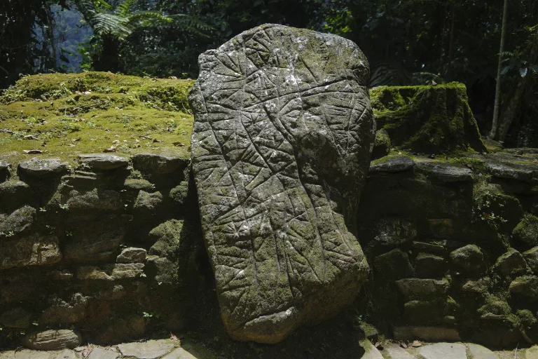
Santa Marta, Presidential visit to the Teyuna Archaeological Park – Lost City/REPÚBLICA DE COLOMBIA, Public domain, via Wikimedia Commons
The communities connected to Teyuna
Ciudad Perdida lies within the ancestral territory of four Indigenous peoples: the Kogi, also known as Kággaba; the Arhuaco, or Iku; the Wiwa; and the Kankuamo.
These communities maintain cultural, spiritual and historical connections to the Sierra Nevada de Santa Marta. Their relationship with the mountains extends beyond individual archaeological sites to encompass the rivers, forests, peaks and wider territories that sustain their traditions and ways of life.
For these communities, the Sierra Nevada is not simply a scenic mountain range. It forms part of a living cultural landscape, where the health of the natural environment and the wellbeing of its people are closely intertwined.
Teyuna should therefore not be understood simply as an abandoned city. Its importance continues through the living heritage of the Indigenous peoples who recognise the landscape as part of their ancestral world.
Respecting cultural and spiritual traditions
The Sierra Nevada is a place where environmental conservation and Indigenous belief are closely connected. Traditional authorities continue to emphasise the importance of caring for the land and respecting places with spiritual significance.
In October 2026, this relationship was reflected in a temporary closure of the archaeological park. Following a request from Indigenous traditional authorities, ICANH announced that the site would close from 1 to 15 October to allow a period of rest for the land and time for internal spiritual practices.
The park subsequently reopened to visitors on 16 October 2026, with its usual published opening hours of 07:00 to 15:00. The decision illustrates why access to Teyuna cannot be understood solely in terms of tourism schedules: Indigenous cultural and spiritual practices are an important consideration in the management of the site.
Travellers can approach the experience with greater understanding by listening to authorised guides, following local protocols and recognising that visiting an archaeological site does not mean every part of the surrounding landscape is open for unrestricted exploration.
The demanding trek to Ciudad Perdida
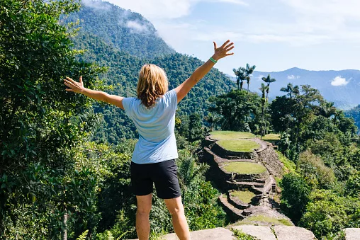
Hiker enjoy the Panoramic view on the terraces of the Lost City (Ciudad Perdida) in the Sierra Nevada de Sante Marta- Santa Marta/ Magdalena/ Colombia/By: Joerg Steber/iStock
A journey through Colombia’s rainforest
Reaching the Lost City requires considerably more effort than travelling to a conventional sightseeing attraction. The journey generally begins in Santa Marta, a coastal city that serves as the main base for arranging guided treks into the Sierra Nevada.
From Santa Marta, travellers continue by road towards the rural settlement of Machete Pelao, also known as El Mamey, where the walking route begins. The trail leads through forested hills, river valleys and rural communities before reaching the archaeological park.
Most itineraries take four days for the return journey, although three- to six-day options may be available depending on the operator and route. The walk involves humid conditions, steep climbs, muddy paths and river crossings. Heavy rainfall can make sections of the trail particularly challenging.
Accommodation is generally in basic camps along the route, where hikers can rest, eat and prepare for the next day. The experience is a far cry from a conventional sightseeing holiday, demanding physical effort and a willingness to travel at the pace of the landscape.
Climbing the final stone staircase
One of the most memorable parts of the journey comes near the end, when hikers approach the archaeological settlement and climb approximately 1,200 stone steps leading towards the terraces.
The ascent provides a fitting introduction to the city itself. After days spent navigating forest trails and river crossings, the stones lead into a network of carefully shaped platforms, winding paths and green slopes.
The site is best explored slowly. Take time to observe the circular foundations, the arrangement of the terraces and the way vegetation surrounds the archaeological remains. The setting helps visitors appreciate the practical challenges faced by the builders and the scale of their achievement.
After exploring the ruins, hikers return along the same general route towards the trailhead. Good preparation, suitable footwear and a realistic understanding of the terrain are essential.
What to experience along the way
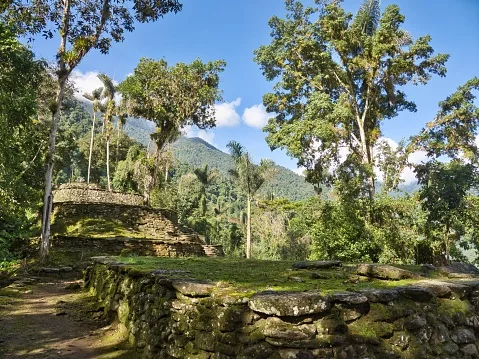
This 4-day trek is 44 kilometres long, and it is an archaeological site, also named Teyuna/By: Judith Engbers/iStock
Forest trails and river crossings
The journey to Ciudad Perdida offers more than the destination alone. The trail passes through tropical ecosystems shaped by changes in altitude, rainfall and terrain. Forest canopies, tangled roots, streams and riverbanks provide a constantly changing backdrop to the walk.
River crossings are a feature of the route, and conditions can change after heavy rain. Hikers should follow their guides’ instructions and avoid attempting crossings when water levels or currents make them unsafe.
Birdlife, tropical vegetation and the sounds of flowing water add to the experience, although wildlife sightings are never guaranteed. The forest is a living ecosystem rather than a backdrop created for visitors.
Rural settlements and local knowledge
The route also passes through inhabited areas and Indigenous territories, offering opportunities to understand that the mountains are not an empty wilderness. Communities continue to live and work in the region, maintaining relationships with the land that long predate modern tourism.
Travelling with an authorised guide helps visitors navigate the route safely and provides context about the landscape and its cultural significance. Local guides, cooks and other trekking staff also contribute to the visitor experience, making responsible tourism an opportunity to support people working in the region.
Visitors should ask before photographing people, homes or culturally significant activities, and respect any restrictions communicated along the trail.
Planning a responsible visit
When to go and what to expect
The climate in the Sierra Nevada is humid and can be very rainy, so even a favourable forecast should not be taken as a guarantee of dry conditions. Trails can become slippery, and the combination of heat, humidity and steep terrain can make walking strenuous.
Allow enough time for the full trek, build in opportunities to rest and choose an itinerary that matches your fitness level.
- Sturdy walking shoes,
- lightweight hiking clothing,
- a waterproof jacket,
- insect repellent,
- sun protection,
- a reusable water bottle
- small daypack are useful essentials.
- A dry bag can also help protect electronics and important belongings during wet weather and river crossings.
Travellers should book through authorised operators and check the latest access information before departure. The trail is not clearly marked throughout, and independent hiking is not permitted. A certified guide is required, so visitors should arrange their trek in advance and confirm exactly what the package includes.
Checking access before departure
The reopening announced for 16 October 2026 is an important current update, but it should not be treated as a guarantee of uninterrupted access in the future. Temporary closures can occur for cultural and spiritual observances, conservation, safety or other operational reasons.
Before setting out, check the latest announcements from ICANH and confirm arrangements with an authorised trekking operator. The park’s published opening hours are 07:00 to 15:00, but you must organise the multi-day hike and accommodation separately.
Respecting closures and local instructions is part of responsible travel, not an inconvenience to be worked around.
Travelling with respect
The site’s remote setting does not remove the responsibilities that come with visiting a protected cultural landscape. Stay on designated paths, avoid climbing on or moving stones, take all rubbish back out and follow guidance about photography and restricted areas.
Travellers should also recognise that Indigenous communities have a voice in how their ancestral territory is cared for and accessed. Choosing an authorised operator, following the guide’s instructions and treating local people with consideration can help make the experience more respectful for everyone involved.
A journey into Colombia’s past and present
Ciudad Perdida rewards those willing to make the journey. Its stone terraces and ancient stairways reveal the ingenuity of the people who shaped a settlement high in the Sierra Nevada. At the same time, the surrounding rainforest offers a powerful reminder of the natural environment in which it developed.
Yet the significance of Teyuna extends beyond its archaeological remains. Its connections to the Kogi, Arhuaco, Wiwa and Kankuamo peoples make it part of a living cultural landscape, where heritage, spirituality and environmental care remain intertwined.
The temporary closure in October 2026 serves as a timely reminder that the site’s future depends on more than preserving its ancient stones. It also requires respect for the communities whose ancestral connections to the mountains continue to inform how the landscape is protected.
Follow us on social media for more travel news, inspiration, and guides. You can also tag us to be featured.
Instagram | Facebook | Twitter | Spotify
ALSO READ:
Aït Benhaddou: The Moroccan earthen village built from the landscape